
CONTENTS
- A Brief History of Downtown Langley
- The Beginning
- A town is born
- The Plan
- The First Building
- First Street
- Anthes Avenue
- Fire
- Automobiles and Garages (1915 - 1930)
- 1930 - 1950
- Second Street
- 1950 - 1990 (More buildings along Second Street)
- 1990s
- Langley Village
- Langley’s Street and Alley Names
A Brief History of Downtown Langley
The Beginning
For centuries Whidbey Island was home to major and minor indigenous tribes. The Skagit tribe inhabited land above the head of Holmes Harbor. The Snohomish tribe occupied lands to the south, southern Camano, and parts of Snohomish County. These Northern Puget Sound Salish Tribes shared a common Northern Lushootseed language.
In the late 1700s and early 1800s native populations were decimated by disease transmitted by contact with euro-american explorers and settlers. In some area’s diphtheria, smallpox, tuberculosis, and measles killed 90 percent of the population. Following passage of the 1855 Treaty of Point Elliott, tribes ceded their lands forcing them to leave and relocate to the Tulalip reservation on the mainland. Some of the Snohomish Shelton Clan descendants stayed behind or returned to the island.
The Snohomish maintained seasonal and permanent villages across South Whidbey. One of the largest permanent villages was located in the greater Langley area, currently identified as Sandy Point (and prior Brown’s Point). Known as THEHT-skluhs or "Ragged Nose" The site housed a major Potlatch Center. Its clam beds drew indigenous visitors as far away as the central coast and Snohomish River valley. Captain George Vancouver noted in his journals that Master Joseph Whidbey saw over 200 people at this site when his ship circumnavigated the Island in 1792.
A town is born
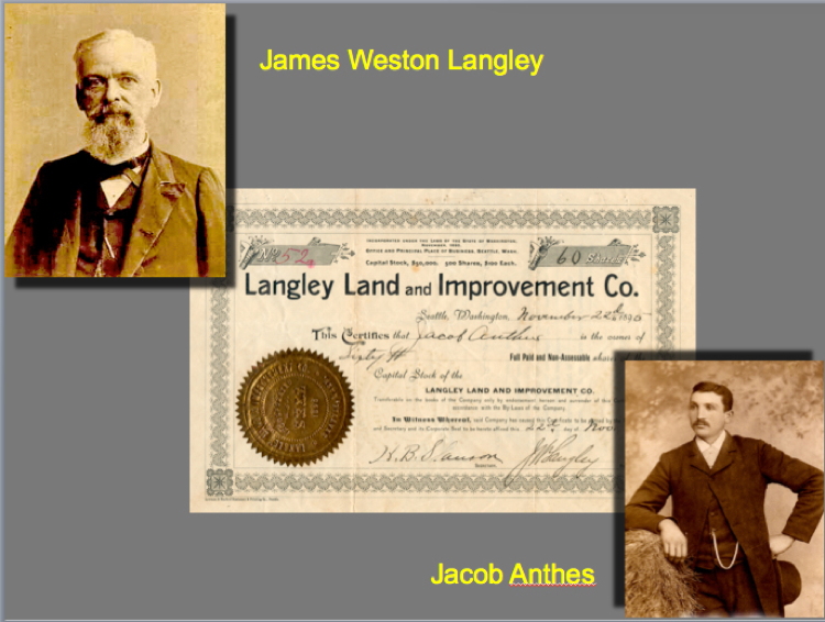
1890. Langley Land and Improvement Company certificate with Judge Langley and Jacob Anthes (Courtesy Robert Waterman).
The railroad was pushing north from Seattle in 1890, and several town sites were being platted on Whidbey Island in anticipation of the prosperity it would bring. Congress also mandated that Washington, as a new state, must have a home for Veterans, and 25 year-old Jacob Anthes felt that Whidbey Island could be a potential site for such an "old soldier's home."
Jacob immigrated from Germany in 1879 at age 14 and had lived on South Whidbey since he was 15. Now, recently married and with their first child on the way, he persuaded several Seattle investors to form a development company - The Langley Land and Improvement Company. He then purchased a tract of land along the shore of South Whidbey overlooking Saratoga Passage in November, 1890.
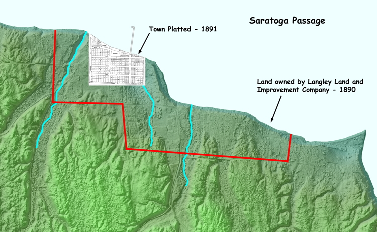
A town with 244 lots named for the president of the Improvement Company, Judge James Weston Langley, was platted and filed with the County on April, 1891.
A wharf to accommodate the Mosquito Fleet steamers was essential. It was placed at the lowest point of the bank. Unfortunately, it needed to extend almost 1000 feet to reach deep water making it susceptible to storm damage.
The Plan
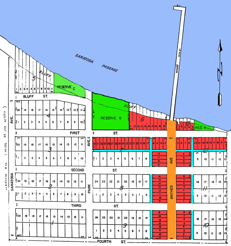
1891. Original Langley plat (color added) (Courtesy South Whidbey Historical Society).
The developers' concept for the town can be seen by looking at the original plat. The wharf was to be the focus of commercial and passenger traffic arriving and leaving the town. The widest street in town (orange) lead to the wharf, and Jacob named this main street for himself, Anthes Avenue.
Lots lining Anthes Avenue and for several blocks of First Street (red) were meant for commercial establishments. Alleys (blue) were located behind these lots to provide for deliveries and waste removal.
Three reserves (green) were located along the bluff. The largest, Reserve B, was set aside for a community park, and the street leading to it was named Park Avenue. The park never materialized and the reserve was subdivided into lots in 1907.
In 1909, the east end of the Street, that lead directly to the bank in the original plat, was angled to allow the street to follow the curve of the bank creating a bend in the street.
The First Building
The first commercial building in Langley was Jacob Anthes' General Store built in 1891 at the Southeast corner of First and Anthes Avenue. Anthes also served as Langley's first postmaster from 1891 to 1904.
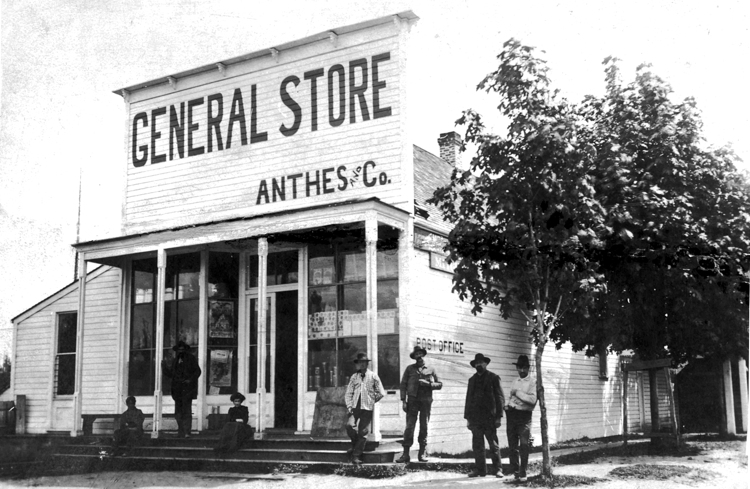
1894. Jacob Anthes' General Store and post office (Courtesy Helene Ryan).
Its placement made it the first business people would see as they came up into town from the wharf. Jacob would sell them supplies and perhaps a piece of property.
He planted small maple trees along both sides of Anthes Avenue and for a short distance along the south side of First Street. He also built a bunkhouse on Second Street for the loggers he hired to clear the town site and cut cord wood to sell to the steamships of the "Mosquito Fleet."
The Anthes store was the only commercial building in Langley during the economic depression that lasted from 1893 until 1897 when a shipment of gold from the Yukon arrived in Seattle setting off a rapid recovery for the Puget Sound region.
The Town Begins to Grow (1900 - 1915)
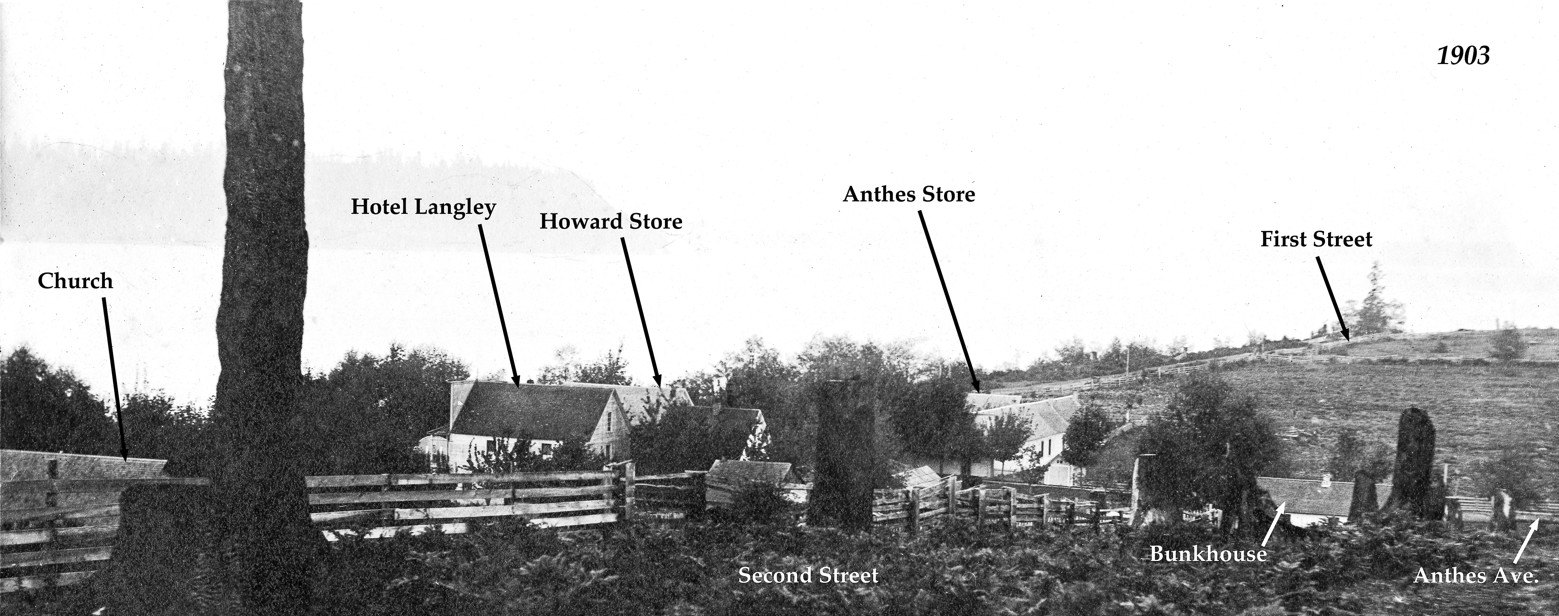
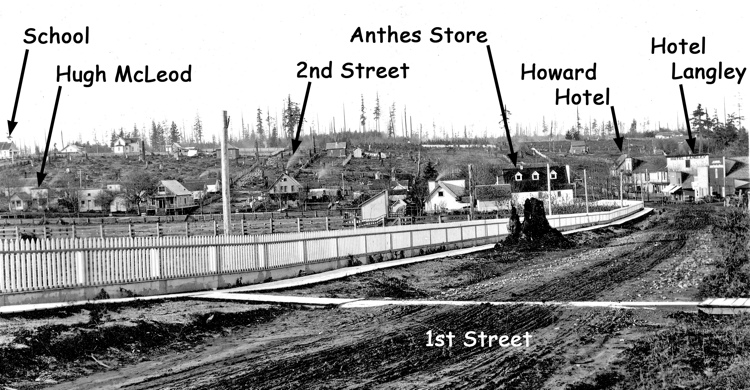
1903. Downtown Langley as seen from Second Street near Park Avenue (Courtesy South Whidbey Historical Society).
First Street
Settlers began arriving as the 20th Century began and steamships returned to the Island. Although the wharf was relocated around the point in 1902, the commercial area of town continued developing as foreseen in the original plat.
The first new commercial buildings appeared along the South side of First Street.
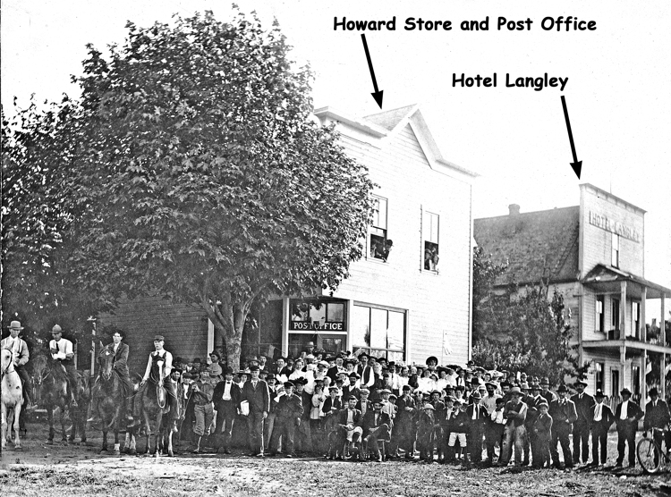
1906. Town portrait, July 4, 1906 (Courtesy Delores Cobb).
A small hotel was built next to Howard's Store, and a community church and adjacent parsonage built a little further up the south side of First Street.
The first commercial structures on the north side of First Street was a much larger "Hotel Langley" with an adjacent "Tourist Park" built across First Street from the original hotel.
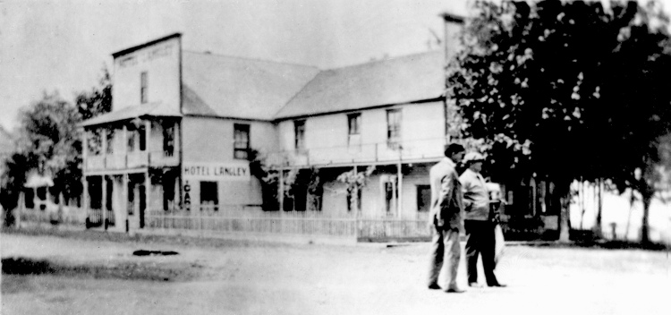
Circa 1907. Hotel and Tourist Park (Courtesy Island County Historical Society).
Ed Howard and his son-in-law, Roderick McLeod, built another hotel a few lots up the street in 1905.
Circa 1908. First Street looking East from near Park Avenue (Courtesy Maureen Duryee).
There were no businesses on the North side of First Street East of Anthes Avenue In 1903.
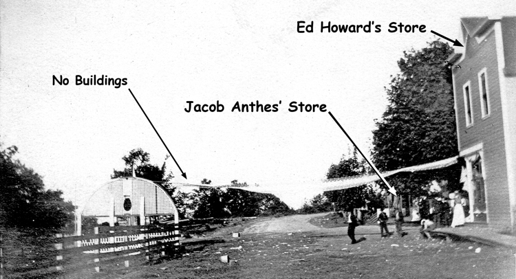
1903. Looking East on First Street (Courtesy Joan Handy).
Businesses appeared along the north side of First Street East of Anthes Avenue between1904 to 1907. These included a confectionary and pool hall, Meat Market, Barbershop, Blacksmith shop, and Livery Stable.
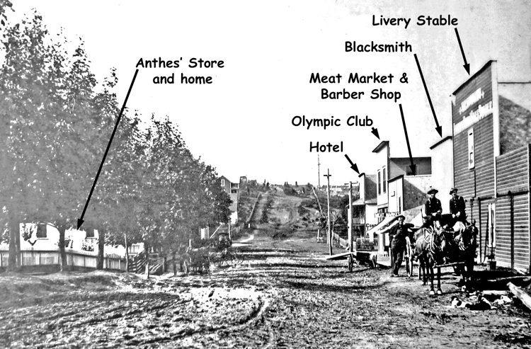
Circa 1909. First Street looking West (Courtesy South Whidbey Historical Society).
An "Olympic Club" was built across from Anthes' store in 1908. This was to be a venue for sporting events, but the grand opening was a disaster when the promoter absconded with the funds stranding a large number of people.
Anthes Avenue
Buildings on also began appearing along the West side of Anthes Avenue in the early years of the 20th Century.
A road to Coupeville was completed in 1902, and traffic from the North entered Langley on Third Street where the maple trees planted by Jacob Anthes directed them North toward First Street.
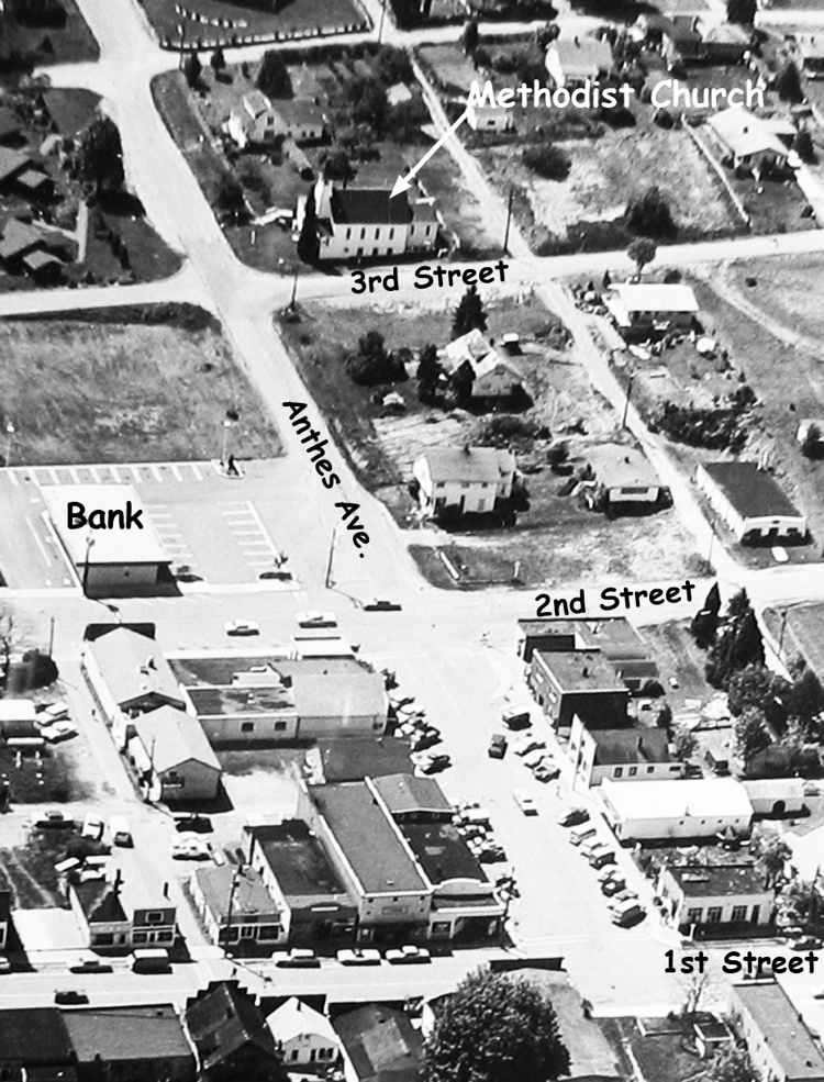
1909. Methodist Church at Third Street and Anthes Avenue (Courtesy South Whidbey Historical Society).
A Methodist Church was built at the corner of Third Street and Anthes Avenue in 1909.
Hugh McLeod built a small law office between Second and Third Streets in 1900. He sold real estate, and served for many years as Justice of the Peace.
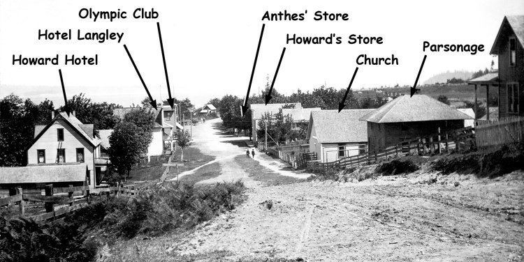
1906/1907. Looking East from First Street (Courtesy South Whidbey Historical Society).
A town pump adjacent to it provided a cool drink for travelers and horses, and a small building next door served as Langley's first telephone office.
Circa 1908. Town pump in front of Hugh McLeod's Justice of the Peace office (Courtesy South Whidbey Historical Society).
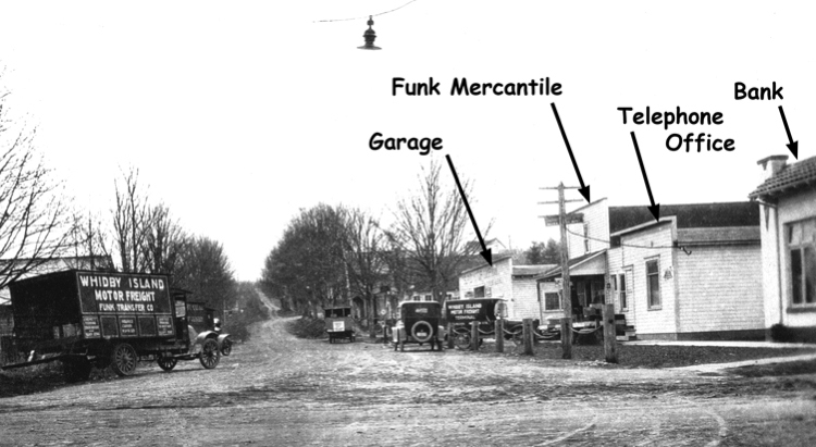
A little further down Anthes Avenue, Fred Funk operated a Mercantile between First and Second Streets in 1910.
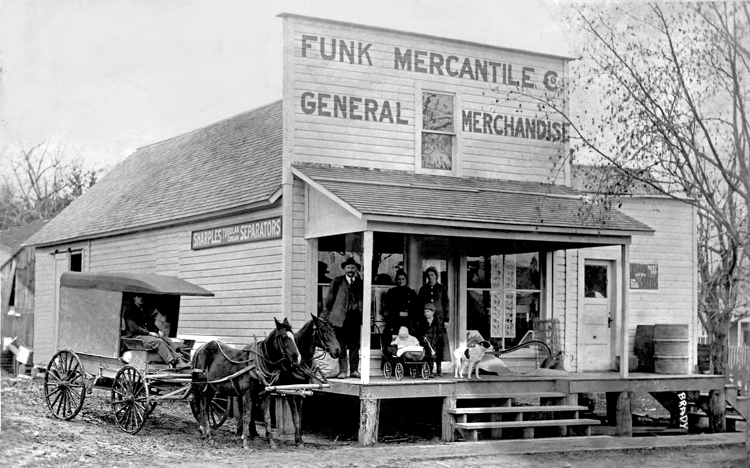
1912. Funk Mercantile at the corner of Anthes Avenue and McLeod Alley (Courtesy Hilma Brown).
Fire
A series of fires drastically altered the look of the intersection of First Street and Anthes Avenue.
1910. Jacob Anthes (center) surveying the ruins of his store and home (Courtesy Helene Ryan).
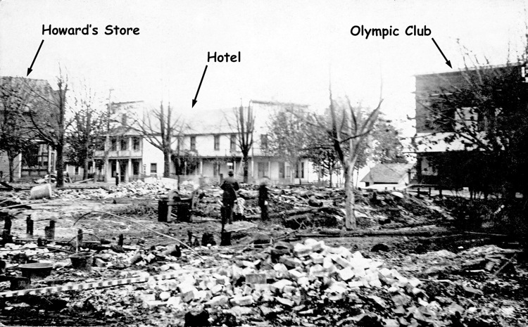
Anthes' store and home burned on October 23, 2010. Arson was strongly suspected but never proved.
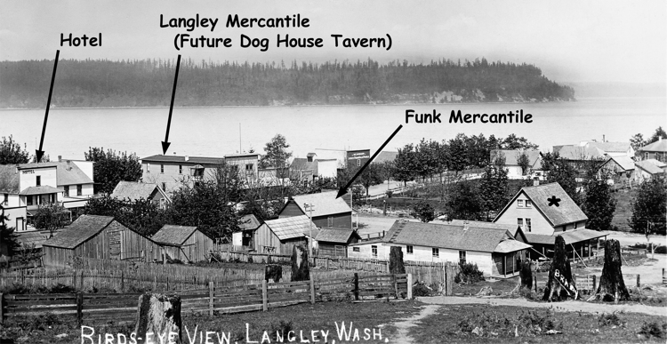
A short time later, Ed Howard's store burned "under suspicious circumstances," and Howard moved his store and Post Office into the Olympic Club renaming it the Langley Mercantile. It later became Howard's Confectionary, then the Dog House Tavern.
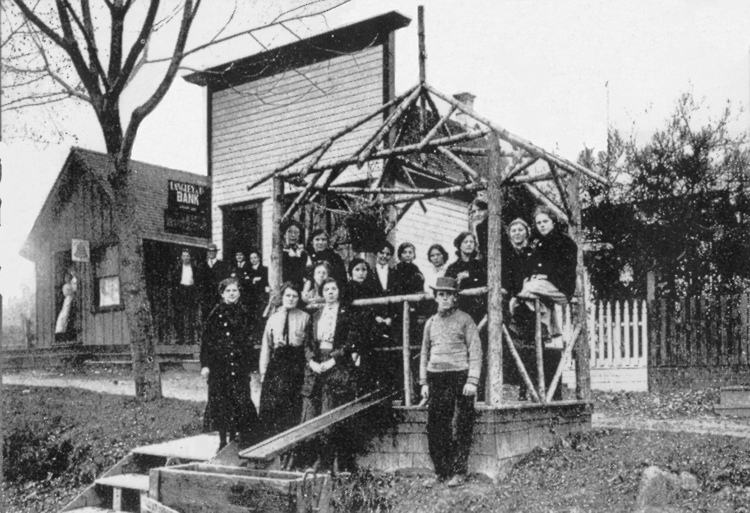
Circa 1912. Bird's eye view of downtown Langley as seen from Second Street (Courtesy South Whidbey Historical Society).
A small wooden Langley State Bank was built in 1914 on the site of Ed Howard's former store. It was replaced by a more substantial bank building in 1922/23, but the lots across Anthes Avenue where the Anthes Store had burned remained vacant for 25 years.
The large hotel burned in 1921, leaving the Olympic Club (Dog House Tavern) as the only one of the four buildings that originally anchored the intersection. That lot remained vacant until a post office was built there in 1938.
The two-story home at the corner of Second Street and Anthes Avenue burned in the mid 1920s.
Automobiles and Garages (1915 - 1930)
Circa 1929. Looking South Along Anthes Avenue (Courtesy South Whidbey Historical Society).
The first automobiles appeared in Langley around 1910. As their number increased, garages were built to service them. Fred Funk and his brother Chris installed the first gasoline tanks to serve the trucks of their transfer service, and one of the Funk sheds was transformed into a garage.
Carl ("Charlie") Lenz constructed a garage on First Street in 1919. It burned in 1932 and was replaced with a more substantial one.
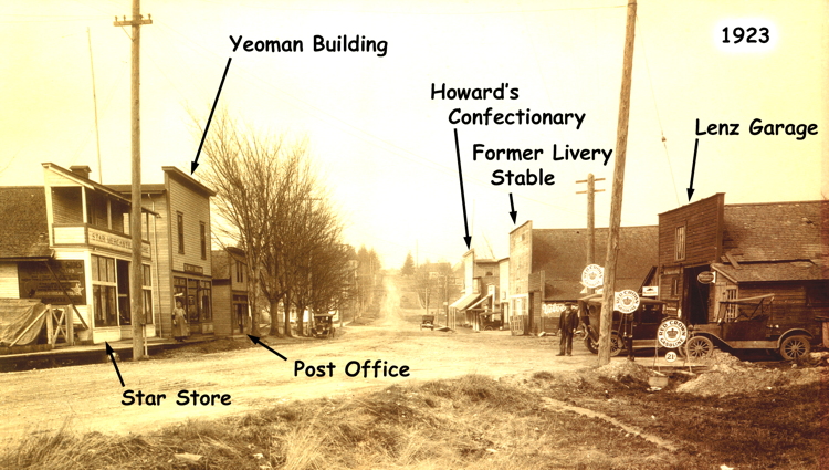
1923. First Street looking West (Courtesy South Whidbey Historical Society).
More buildings appeared along the South side of First Street including a new Post Office and the Star Store.
Businesses were slower to appear along the East side of Anthes Avenue. The only business along the East side of Anthes Avenue in 1929 was Norman Clyde's first garage.
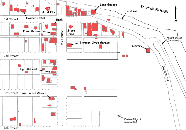
1929. Buildings based on Sanborn Insurance map with color added (Courtesy Robert Waterman).
1930 - 1950
Buildings filled both sides of First Street by 1940, including the Norman Clyde Garage and Theatre built on the site of the former Anthes' store in 1935 and 1937 respectively, and a drug store built in 1937.
Circa 1940. First Street looking East (Courtesy South Whidbey Historical Society).
Second Street
Development along Second Street lagged behind that on First Street and Anthes Avenue, and Second Street was not connected with Cascade Avenue until the 1930s.
The Public Library dedicated in 1923 at the intersection of Second and Cascade Avenue and two residences were the only buildings along the North side of Second Street between Anthes and Cascade Avenues in 1944. There were no structures along the South side.
Circa 1944. Looking East on Second Street (Courtesy Francis Johnson).
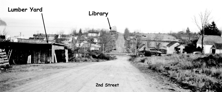
A small lumber yard was the only business along the North side of Second Street between Anthes and Park Avenues.
By 1950, the Masonic Temple, completed in 1948, was separated by three residences from a small propane office and the Frick Hardware and Garden Supplies building constructed in 1946.
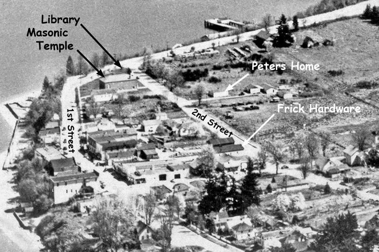
1952. Aerial view of Langley (Courtesy South Whidbey Historical Society).
The only structures on the south side of Second Street were the Peters home and outbuildings, and a small structure near Anthes Avenue that may have housed the town's fire truck and a small jail. A wooden firehouse was constructed next to the Peters home in 1953 but burned a few years later.
1950 - 1990 (More buildings along Second Street)
A doctor's clinic was completed along the north side of Second Street in 1968, and the former Frick Hardware and Garden Supplies building was now Skipper's Inn Restaurant.
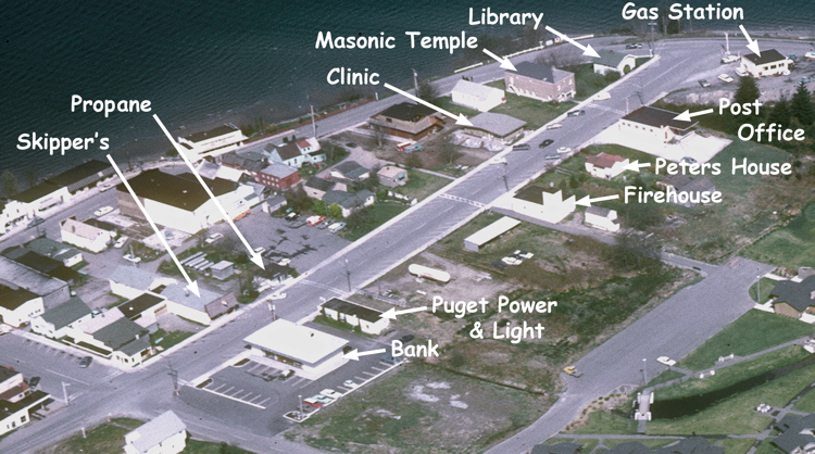
1971. Aerial view of Second Street (Courtesy Ben Breedlove).
By 1966, a Chevron gas station, Post Office, new Firehouse, and the Puget Power and Light building had appeared along the south side of Second Street. Old cars were stored in a shed next to the Firehouse, and a large propane tank occupied the adjacent vacant lot.
A People's Bank (later U.S. Bank) was built at the Southeast corner of Anthes Avenue and Second Street in 1970.
Circa 1975. Aerial view of Anthes Avenue (Courtesy South Whidbey Historical Society).
By 1970, buildings along the West side of Anthes Avenue between First and Second Streets included a Norman Clyde Motors showroom built in 1940, and a Body Rebuild shop and gas station built by Lloyd Carter built in 1950 and 1952 respectively.
A low income housing project was constructed between Third and Fourth Streets in 1969, and a two-story commercial building was constructed in the lot south of the bank in 1983.
1990s
The last buildings to appear along the South side of Second Street between Cascade and Anthe Avenues were constructed between the Firehouse and Puget Power and Light building.
First to appear were Linda Anderson's realty building in 1973 and Robert Sleights's Chiropractic office in 1984.
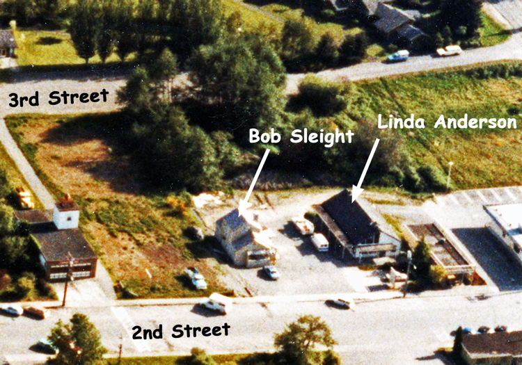
1985. Bob Sleight's and Linda Anderson's buildings on the property that became the Langley Village (Courtesy Delores Cobb).
Three buildings designed by architect Ross Chapin were constructed in the early 1990s in the lot between the firehouse and Bob Sleight's building.
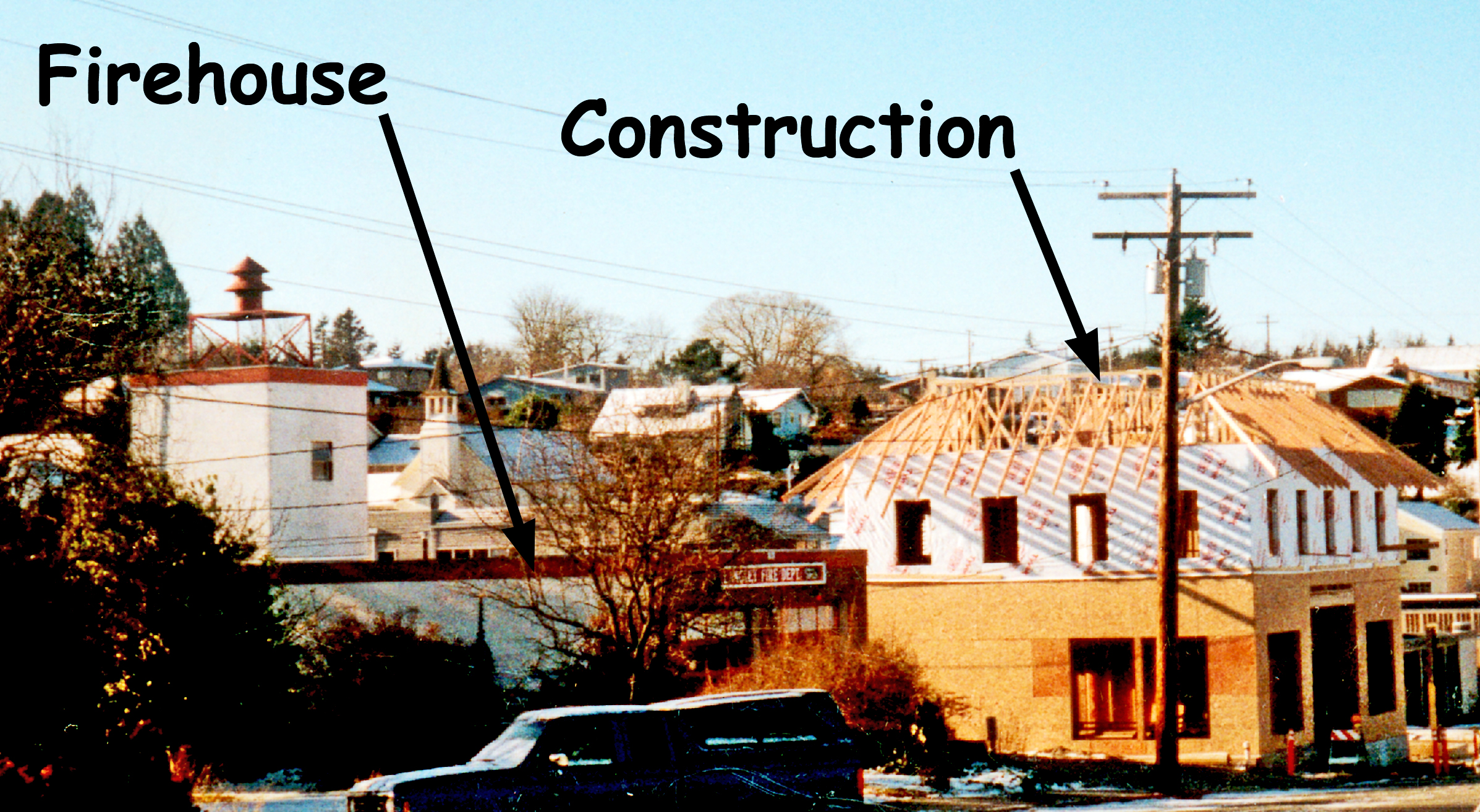
1990. Construction next to the Firehouse on Second Street (Courtesy Delores Cobb).
A group of buildings that became the Langley Village were also constructed in the 1990s.
Langley Village
The following history of the Langley Village was provided by Robert Sleight:
"Bob Sleight and Linda Anderson were the original partners on the development of Langley village. Linda owned the land and had built her Real Estate office there in 1973.
The first building in what was to become Langley village was the chiropractic office built in 1984 by Bob and Linda Anderson where Bob had his chiropractic practice for about 25 years. It stood alone and was there before any of the rest of Langley Village was developed.
We originally thought a health club to be called Village Health Club would be wonderful use for the rest of the property. We had an architect in Seattle draw up the plans to make that a reality. With the help of Janet Ploof, we signed up over 250 members and they paid a fee to make that a reality. Over time we discovered that it would not be economically feasible and we abandoned that plan and totally refunded the money.
I came up with the idea of the Village in a discussion with Dale Elliott who was to become the architect of the project. I was sitting in Skipper's restaurant having a discussion with Dale and drew my idea on a napkin. The plan was to have residences upstairs and commercial buildings downstairs where people would be able to live and work. Many discussions with Linda Anderson followed. Linda was a great friend and a wonderful business partner on many things that we did together.
We hired Dale to draw up some preliminary sketches and ideas. He worked diligently for two years and interfaced with Linda and myself to come up with final renderings that later became the basis for the plan as it is today. It was a long process of working through some tedious concerns regarding growth the city had at the time. In all fairness the plan encompassed 20% or so to the entire city of Langley so it was a major endeavor.
We were finally able to get a binding site plan approved. Dale Elliot was the architect on the project. Steve Arnold was the contractor, and Fran Able was the landscape architect and designer. We added a partner, Jim Mock, in the late 80s.
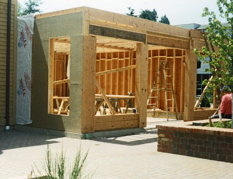
1992. Construction in the Village underway (Courtesy Betty Davenny).
Construction started on the infrastructure of the total plan. Linda and I were very concerned as we loved Langley and wanted the village to be like a park. We desired that the infrastructure and the landscaping would create that environment. Every building exterior had to be approved by Dale Elliot, Linda Anderson and Bob Sleight before the city would issue a building permit, and it had to be exactly the way Dale had designed the exteriors.
The entire project was finished by the late 1990s. Every building was built and infrastructure and final landscaping were completed. A beautiful addition to Langley."
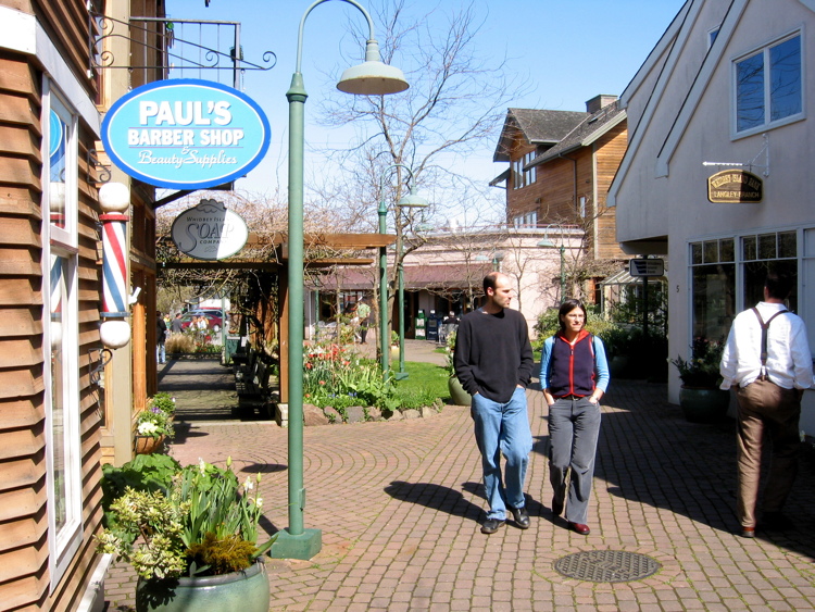
2007. Langley Village (Courtesy Robert Waterman).
Click here to view the timeline maps for the history of downtown Langley.
Langley’s Street and Alley Names
Streets
| Al Anderson Avenue | Named in for Albert Anderson, son of Anders ("graveyard") Anderson who owned 20 acres along the road. It was also known at various times as Mt. Baker Road, Cemetery Road, and Anderson Road. |
| Anthes Avenue | The widest street in town named for Langley’s "founder," Jacob Anthes, who built the first store and Post Office at the corner of First Street and Anthes Avenue in 1891. |
| Brackenwood Avenue | Formerly "Goodell Lane" named for Ansell Goodell who lived along it. Was renamed Brackenwood in 1996. Brackenwood was the name given to the artist colony created by Peter and Margaret Camfferman in the early 1900’s along the bank above Saratoga Passage at the end of the lane. |
| Canfield Drive | Pam and Ron Lind built the road in 1989 and named it Canfield after Pam’s Mom. |
| DeBruyn Avenue | Originally "Saratoga Avenue" in the 1891 town plat, it was renamed in 1977 in honor of the DeBruyn family who lived on the west side of the avenue. |
| Dalton Lane | The one-lane road that runs between the fairgrounds and the old middle school was named in the late 1950s or early ‘60s for Leonard (Michael) Dalton Sr. to reach property owned by Leonard and his wife Dorothy. Since the lane didn’t have a name at the time, Mr. Dalton proposed naming it after his family. His son said it didn’t hurt that his father had just made a $500 donation to the City when he made the request. |
| Decker Ave. | Named for Jerome (John) Decker, father of Sgt. William J. Decker. Jerome was born in Michigan in 1853 and died in Langley in the early 1940s. |
| Edgecliff Drive | According to a story by Nora Wickstrom: the area was named "Edgecliff" by Jane Potts, who lived along the road., The road was named "Furman Road" as late as 1956. |
| Frick Lane | Named for Wallace Henry ("Wally") Frick who built a machine shop there in 1946. A second building added later north of the original structure served as a garden store with an apartment above. Wally's wife Sallie ran the garden shop and operated a small nursery. |
| Furman Avenue | Named for Frank E. Furman, first mayor of Langley (1913) who owned property in the area. |
| Groom Lane | Named for Jim Groom, construction manager for Robert K. Porter (RKP) Enterprises that built many homes in the area. |
| Louisa Street | Named for Louisa Pereira Aguiar. Louisa came to Whidbey in the 1970s from the Azores and purchased several lots south off Anderson Road. She died in 1978 and is buried in the Langley cemetery. |
| Luhn Avenue | Formerly Clyde Ave. named for the Clyde family. Renamed in 1996 for Richard. A. Luhn who owned property there. |
| Manchester Way | The street next to the Firehouse leading from Cascade Avenue to the Saratoga Terrance housing development was named for Langley dentist and mayor, Donald Manchester. |
| Minnie Lane | Named in 2009 for Minnie Dexter who came to Langley with her husband Wayne following WWII. They lived on the lane in a renovated chicken coop, and Minnie worked in the Star Store for many years. She died in 2015. |
| Park Avenue | Presumably named for "Reserve B" that Jacob Anthes had set aside a for a park when the town was platted in 1890. This was divided into lots in 1907 when the idea of a park was abandoned prior to the Anthes family’s move to Everett. |
| Sandy Point Road | Created when a landslide forced closure of a portion of the original road (now Edgecliff Drive) to Sandy Point. |
| Saratoga Creek Lane | Named in 1996 for the Saratoga Creek that runs at the bottom of the ravine east of the lane and empties onto the beach below. |
| Wharf Street | Wharf Street leading to the Marina used to be designated "Anthes Road 25 to the Dock". |
Alleys
| Clyde Alley | Land for this Alley next to the Firehouse on 2nd Street was donated to the City by Norman and Hazel Clyde, May 4, 1955. |
| McLeod Alley | Named for the McLeod family in 1996. |
| Melsen Alley | Named for Albert Melsen, contractor and mayor of Langley for multiple terms. Initially ran only between 1st and 4th Streets. |